Posts

To Meteorologists: Regarding "Landspouts"

Image
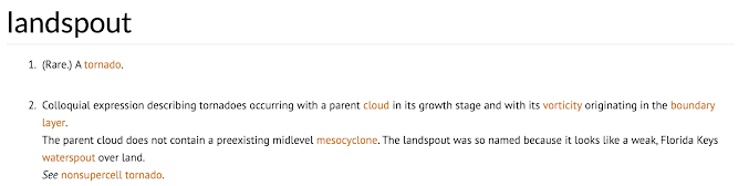
Dear Colleagues, I don't know what prompted the fad of calling tornadoes "landspouts" but, in my opinion, it should stop. Here is the definition of a landspout per the Glossary of Meteorology: Note that it states: The parent cloud does not contain a preexisting midlevel mesocyclone... See non-supercell tornado . [emphasis mine] There were at least three tornadoes called "landspouts" yesterday. This was from Kansas. The tornado shown above came from the mesocyclone associated with the tornado warning at lower left. There was a large tornado a few minutes later. I don't know whether the pictured tornado grew or whether it was what is correctly called a "satellite tornado." Same thing in Texas. At right, the mesocyclone at the time of the "landspout" report is clearly visible.  All we are doing with all of these (incorrect) landspout reports is confusing people! Landspouts are dangerous tornadoes, so we want people to take exactly the same s

Updated Tornado and Giant Hail Forecast (8:20pm Update)

Image
The line of thunderstorms coming out of Colorado may sweep across Kansas during the night. If so, it has the potential to cause damaging winds and power outages.  Severe thunderstorm watch with tornadoes possible until 2am. Severe thunderstorm watch with tornadoes possible for southeast Texas. Tornado watch until midnight. A thunderstorm is already developing southeast of Scott City. This tornado watch has been issued until 11pm. Please keep up on the weather in these areas as thunderstorms have already begun developing.  This is my least favorite type of watch: if tornadoes are possible, my opinion is that it should be a tornado watch. Regardless, tornadoes, 3" hail and thunderstorm-generated winds to 80  mph are forecast to occur in southwest Texas.  -- forecast from now until 3am Thursday is below -- I have updated the tornado forecast because there is a boundary appearing on satellite over northwest Oklahoma that should move north into south central Kansas this afternoon. This

Gift for Mom or Graduate

Image
There are few better gifts than a book. And, for someone with an interest in weather, there is no better book than this (17th best selling book about weather of all time!).  Written in the style of a novel, it is gripping in places and touching in others. You can purchase a copy here .

Today's Tornado Forecast

Image
The area in brown has a significant risk of tornadoes. There is the possibility that this forecast will have to be upgraded in places at midday. Please check back. 

Rainfall and Hail Tracks

Image
Storm total rainfall to 9pm CDT Tuesday. Hail tracks. Three inch hail feel in Harper Co., Kansas and very large hail fell in southwest Oklahoma where it may have damaged the winter wheat. 

This Evening's Kansas Sky

Image
There is nothing like the Kansas Sky. All three photos were taken this evening. These are cumulonimbus mammatus clouds at sunset; as taken from my back yard.  This is a towering cumulus cloud that would soon turn into a thunderstorm. It was located near Rose Hill, Kansas. These are the types of photos you will see at my site at Adobe Stock Photography . I've submitted several spectacular photos from today, but it takes them time to curate them. Regardless, please click the red link and I believe you will enjoy viewing my photos.

Today's Tornado Forecast [Updated 3:30pm CDT]

Image
Tornado watch until 11pm for most of eastern Kansas and parts of northwest Missouri. It does not  include the Greater Kansas City area.  You can follow my real-time storm coverage on Twitter/X at:  @usweatherexpert .  As of 3:28pm, thunderstorms are forming in south central Kansas. Tornado Watch issued until 10pm for Nebraska and Iowa. It includes Lincoln, Omaha and Des Moines and Sioux City.  In addition to tornadoes, please note that thunderstorm-generated winds of 80 mph and tennis ball-sized hail are also forecast to occur.  The NWS just published this graphing depicting how they expect the severe thunderstorms to develop.  The first severe thunderstorms are forecast to occur in the Lincoln-Omaha-Council Bluffs-Atlantic areas.  --- original posting --- The yellow areas has an enhanced  risk of a tornado. The brown area has a significant risk.  There is also an enhanced  risk of hail 2" or larger in the red area. The yellow hatched area has significant risk. The yellow area wit